It seems that Mary Spence MBE, the President of the British Cartographic Society, thinks so.
I read this article with a considerable amount of interest. Read it for yourself, but the gist of it is that Dame Spence is worried that the rise of satnav in cars and mobile devices, and websites like Google Maps, Mapquest, Rand McNally.com, Yahoo! Maps and others are doing harm and (in some cases) violence to the British landscape and the history behind it. People, according to Spence, want to get from point A to point B and don't care what's along the way. What's more, she continues, the "corporate cartographers" at Google and the like ignore the patchwork of traditional representations of landmarks, ancient woodlands, ruins and historical sites that have been characteristic of British (and Western) maps since the early modern era.
I had multiple reactions to her arguments and the ideas behind them, so lets deal with them in turn. First, we must consider what purpose a map serves? What is it that a map is trying to do? This is rather hard to define precisely, but a good general description is that it is trying to represent a piece of three-dimensional territory in a two-dimensional medium. I know that is a broad and (perhaps) flawed definition, but it is a good starting points.
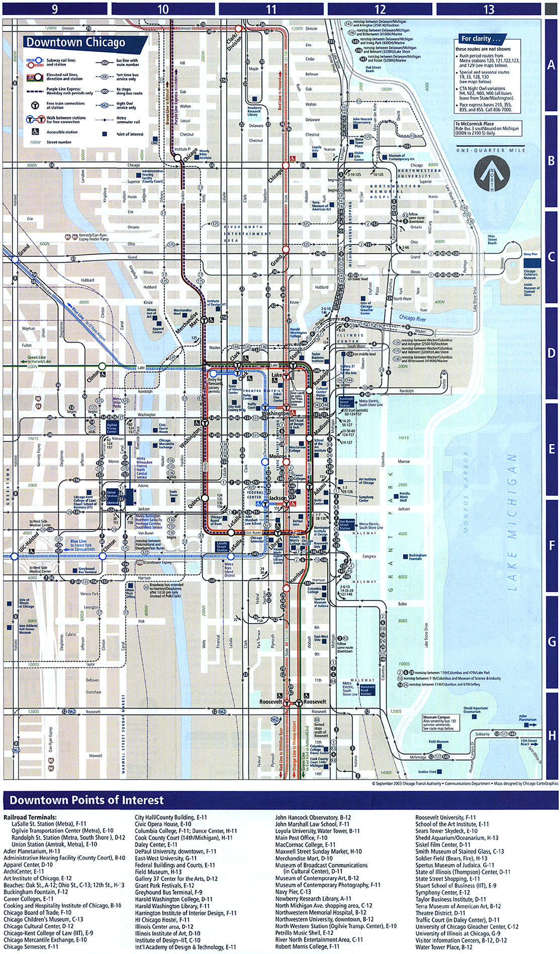
The better answer is that maps have several purposes and their makers often have different goals in mind. You can look at different maps of the same terrain made for different purposes and have it seem like you are looking at three different places. For example, look at these three maps of Downtown Chicago. They essentially depict the same territory, but were made in different times for different purposes (namely, land use, transport and recording a historical event).
Now, when you think about it, a map of the Chicago Fire of 1871 or the CTA map of the Loop is of use to some people, but not to others. What good would a historical map be to a modern apartment hunter? What good would a transit map be to someone entering the city by car? Not much is right. So, I take issue with the notion that using online map services for purposes of practical navigation is a bad thing or something that should be left to paper maps. These services have their place and they are very popular.
Second, I was interested in the way that Dame Spence decided to frame the issue. She framed it, without doing so expressly, in the classic dichotomy of "space versus place" and also from the standpoint of how and what the map depicts and how that relates to the landscape, the built environment and its history.
Space versus place is one of those arguments that academics (mainly geographers, but recently others have gotten in on the action) love to have with each other. Basically, the stripped down version is that a place is a space imbued with some kind of meaning. Here again, this is right from the Department of Tenuous Definitions, but it will have to do. Spence was saying that with satnav and online mapping, places were becoming spaces (in a manner of speaking).
I was also interested in her mention of the lack of historical and archaeological detail on the maps. This concern comes straight out of the maps produced by the Ordinance Survey (OS). Since the 1790's, the OS has been charged with the detailed mapping of the whole of the British Isles and large parts of their (now) former empire. OS maps, starting from their first large body of work mapping Ireland between 1828 and 1836, have a lot of fascinating aspects that tell us as much about the mapmakers as the territories being described.
The original OS maps of the 19th century bespeak of a country concerned with preserving its past but also looking enthusiastically toward its future. Sites of ancient ruins, cathedrals, stone circles and other such historical bric-a-brac were shown along side harbor improvements, the deep cuts for the canals and railways and other such modern bric-a-brac. These maps were bought not only by history buffs, but by land speculators, railroad developers, canal and turnpike companies and towns interested in development and the emerging discipline of modern town planning. They were truly showing the Britain of the 19th century as a place, imbued with meaning and indicative of its times.
These maps saw different users over the years, especially by hikers, bikers and other outdoorsy types. In these users, one can see a desire to maintain the landscape and monuments as a fragment of a deathless Britain even as Britain's imperial century drew to a close. This is along side the fact that, until recently, the best maps of the British Isles were produced by the Ordinance Survey, an executive agency of the British Government.
Thirdly, and this relates to the point above, it was interesting that Spence used the phrase "corporate cartographers" to describe Google and their kind. In defending the traditional (if you can call it that) mapping of Britain by the OS, she seems to be saying that the undying landscape and place of Britain was being hacked to bits or flat-out ignored by these corporate stooges, interested in getting people between locations, history and sense of place be damned.
Here is where I must part ways with Spence a little. Granted, the OS maps of Britain are great and you would have to go a long way to do a better job mapping the whole of a country. I own several OS maps and they are rich in detail and information about the topography and physical character of an area. They are also simply a joy to look at, following the contours in the map and in your mind.
That being said, I also agree that the OS maps have their function, but so does Google and other electronic, satellite maps. If I need quick directions, especially to an unfamiliar place, they are easy and readily available. This does not replace paper maps, which are often needed for greater detail or as a check against mistakes (which do happen with electronic mapping services).
Electronic resources, maps included, have the added advantage of being able to be updated in real-time, allowing travellers and local residents alike to respond to adverse weather conditions, roadwork, disruptions in rail or air transport and other highly variable conditions.
To the larger question of electronic resources "killing" off the extrordinary history of British places, I think that Spence's trepidation is a bit misplaced. Why? The reasons I gave above for different maps for different uses and situations. Quick directions are useful in some situations, but not in others. What use would they be if your intent was to wander around looking for something interesting? Not much, in fact, that activity might be best with no map at all.
So, I think that paper maps are in no danger of extinction because of the vital part they and their details play in how we conceptualize and represent places. They have been part of our symbolic language for centuries and they serve a great purpose. We think cartographically (to some extent) and these cartographic iterations help us to do that in different but not mutually exclusive ways. Google and good, old paper maps are both welcome.
To put it all another way, there is more than one way to answer Burt Bacharach when he asks "Do You Know the Way to San Jose?"
Burt Bacharach and cartography...what a way to end the week.
Do Not Worry
6 years ago
1 comment:
I think it's all about what your intentions are when using a map. If I want to know how to get somewhere in the shortest amount of time without any confusion, I'm going to use mapquest. But, if I'm on a road trip where I don't mind going the road less traveled, paper maps are so much more fun to use.
I found a great post on Peterman's Eye about the use of paper maps in a technological world. It's a great read, and I thought I'd share...
http://www.petermanseye.com/passions/travel/323-on-the-map
Cheers!
Post a Comment